


TOPOGRAPHIC SURVEY
Get ready to elevate your surveying experience with our topographic survey service! We provide an exciting range of aerial and terrestrial surveying solutions, all expertly geo-referenced and tailored to meet your specific needs. With cutting-edge photogrammetry and LiDAR technology, our surveys produce stunning high-resolution 2D orthomosaics, digital elevation models, and immersive 3D models. Plus, for those hard-to-reach areas, our terrestrial surveys utilize SLAM LiDAR technology for impeccable detail in the final point cloud output. Rest assured, our data acquisition processes are meticulously geo-referenced using GNSS technology, ensuring accuracy and reliability in every thrilling project!


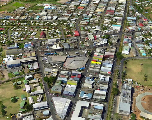
ORTHOMOSAICS
Orthomosaics
Orthomosaics are high-resolution, distortion-free aerial images created by stitching multiple overlapping photos and correcting for terrain variations and camera tilt. These map-like images are used across various fields: in agriculture for crop monitoring and irrigation planning, in urban planning and construction for site analysis and progress tracking, and in environmental conservation for habitat mapping and ecosystem monitoring. They also assist in disaster response by providing accurate maps, archaeology for documenting sites, surveying for land mapping, forestry for managing tree health, and mining for resource monitoring. Their precision makes them invaluable for measurements and analysis in diverse applications.
Photogrammetry 3D Model
Photogrammetry 3D models are digital representations of objects, spaces, or landscapes crafted from numerous photographs taken from various angles. By utilizing specialized software, this technique analyzes the images to identify common points, reconstructing the subject in a detailed, three-dimensional format. The resulting models find applications in fields such as architecture, archaeology, gaming, and virtual reality. For instance, in architecture and urban planning, these models help create precise 3D representations of structures and landscapes, aiding in restoration, construction planning, and design. Photogrammetry 3D models are often exported and stored in file formats that allow for compatibility across various software and workflows.
PHOTOGRAMMETRY 3D MODEL

AERIAL LiDAR
Aerial LiDAR
Aerial LiDAR (Light Detection and Ranging) is a remote sensing technology that uses lasers mounted on aircraft to scan the Earth's surface and generate precise, high-resolution 3D maps. By emitting laser pulses and measuring their return time after reflecting off surfaces, it creates accurate representations of terrain and objects, even through vegetation. This technology is widely used in applications such as topographic mapping, environmental monitoring, disaster management, urban planning, and forestry. It helps with tasks like identifying flood-prone areas, mapping archaeological sites, managing forest resources, and aiding infrastructure development by providing detailed terrain data. Its ability to penetrate dense vegetation and deliver precise measurements makes it invaluable across diverse fields.
SLAM LiDAR (Terrestrial)
SLAM LiDAR (Simultaneous Localization and Mapping with Light Detection and Ranging) is a cutting-edge technology that uses laser scanning to build accurate, real-time maps of an environment while simultaneously tracking the device's location within it. It is particularly effective in dynamic or GPS-denied areas, such as indoors or densely populated urban spaces. SLAM LiDAR has numerous mapping applications, including creating 3D maps of complex interiors for construction and facility management, enabling efficient navigation in robotics and autonomous vehicles, and supporting augmented reality systems for immersive experiences. Its versatility and precision make it a valuable tool across industries like logistics, architecture, and urban planning.

SLAM LiDAR

DIGITAL TERRAIN MODEL
Digital Terrain Model (DTM)
A Digital Terrain Model (DTM) is a 3D representation of the Earth's bare surface, created by removing all natural and man-made objects, such as trees and buildings, to focus solely on the underlying terrain. It provides valuable insights into elevation, slopes, and contours, making it highly useful for mapping and analysis. DTMs are widely applied in fields like urban planning, where they assist in designing infrastructure and drainage systems, and in environmental management for studying watershed areas and erosion. They are also instrumental in agriculture for irrigation planning, in disaster management for modeling flood zones, and in geology for understanding landforms and tectonic activity. Their accuracy and versatility make them crucial for projects requiring precise topographic data.
Contour Lines
Contour lines are curves on a map that connect points of equal elevation relative to a reference level, typically sea level, and are used to represent the 3D features of terrain on a 2D surface. The spacing of these lines reflects the steepness of the terrain: closely spaced lines indicate steep slopes, while widely spaced lines suggest gentle inclines. Contour lines have diverse applications, such as in topographic maps for outdoor activities like hiking and navigation, urban planning for determining construction sites, and agriculture for practices like contour farming that reduce soil erosion. They are also essential for flood analysis to predict water flow, military operations for strategic planning, and hydrology to map watersheds and understand drainage systems. These lines are a vital tool for visualizing and analyzing the Earth's physical layout.

CONTOUR LINES